
Paris – An archaeological mission under the auspices of UNESCO concluded today its 14-day exploration of the Skerki Bank (Tunisia) and the Sicilian Channel (Italy) in the Mediterranean.
For the first time, International scientists from 8 Member States have modeled the shipwrecks and improved the mapping of the area in order to protect important underwater cultural heritage in the long term.
“This mission is the result of unprecedented international cooperation. I thank the eight Mediterranean Member States that worked together to organize and conduct scientific research, under the coordination of UNESCO, based on our 2001 Convention on the Protection of the Underwater Cultural Heritage,” said Audrey Azoulay, Director-General of UNESCO.

Researchers from Algeria, Croatia, Egypt, France, Italy, Morocco, Spain, and Tunisia collaborated on this mission. It took place over 14 days, aboard the French scientific vessel, The Alfred Merlin, in international waters, on the Italian continental shelf, under the coordination of Italy, and then on the Tunisian continental shelf under the coordination of Tunisia.
“It concludes with significant advances, in particular, high-resolution documentation of shipwrecks from the Roman period to the 19th century. This confirms that the Skerki Bank is of the greatest interest for the underwater cultural heritage in the world,” added the Director-General.
High-resolution mapping for the first time
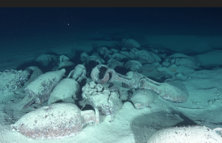
The archaeologists led a survey using two different robots, or, Remotely Operated Vehicles, adapting to the geographical and morphological submerged areas. The robot Arthur, designed especially for archaeological surveys in deep waters, was used to document shipwrecks on the Italian continental shelf.
Arthur documented 3 roman shipwrecks discovered by the American expeditions (Ballard-McCann) in the 1990s. Archaeologists were happy to find that the state of conservation of these shipwrecks and artefacts is almost the same as it was nearly 30 years ago; they have not been impacted by sedimentation, bioerosion, or human activities (fishing nets, etc.).
The new data collected allows for higher resolution photos and videos that help to characterize and date the ships’ cargo. Documenting these sites has uncovered substantial new evidence.
Three new shipwrecks documented
On the Tunisian continental shelf, the archaeologists used the robot Hilarion to verify and document the targets of the newly mapped area. The seabed was also explored with multibeam sonar to give more information about this area, which is unknown and dangerous for navigation, and on the potential location of other archaeological remains.
The area around the Keith Reef was scanned for the first time in order to produce a detailed map showing the traces of underwater cultural heritage. This allowed the scientific and technical team to document 3 new shipwrecks dating from the Ancient to the Modern period (C19th), as well as several other areas of archaeological interest.
What’s next?
This Autumn, the archaeologists will meet at UNESCO to unveil their preliminary findings. A full, detailed report will be presented at a later date. This is the first step in a lasting relationship of multilateral cooperation in the Mediterranean.
The archaeologists plan to process the photogrammetry of the revisited wrecks located on the Italian continental shelf, using the video taken by the robots, and recommend continuing the mapping of the Skerki Bank area on the Tunisian continental shelf. They also want to organize several activities such as a scientific conference, follow-up missions, and a reflection on the protection of these sites.
This multilateral mission is both an opportunity and an example to be shared with other countries as a best practice for the study, protection, and promotion of underwater cultural heritage in international waters.


